
Structural Data
Structural data records the orientation and attributes of geological features such as contacts, joints, and faults. This information can be analysed in Stereonet Charts to understand structural trends and their relationship to excavation surfaces.
Sourcing Geological Structure Data
Geological structure data typically comes from the following activities:
-
Mapping of outcrop, open pit, and underground excavation faces, typically using scan lines.
-
Logging and orientation of drillhole core.
This data can be collected using manual mapping methods, such as tape measures, compasses, specialist geotechnical measuring devices, notebooks, or portable electronic devices. It can also be collected using electronic measuring equipment.
Representing Structure Data
Structural data encountered in a mining or exploration operation typically includes the following geological features:
-
Rock contact - A contact surface between two adjacent, different rock types.
-
Joint - A break in a rock with no relative movement on either side across the break.
-
Fault - A break in the rock mass where the rocks on either side of the break have been displaced vertically, horizontally, or both.
The orientation of a surface, referred to here as a plane, is described by the following parameters:
-
Dip Direction - The direction of maximum dip on a surface. This is the direction water would flow if poured on the surface. It is measured with a compass in a horizontal plane. Values range from 0 to 360 degrees.
-
Dip - The maximum angle that the surface makes with a horizontal plane. A horizontal surface has a dip of 0 degrees. A vertical surface has a dip of 90 degrees. It is measured with a clinometer. Values range from 0 to 90 degrees and are positive.
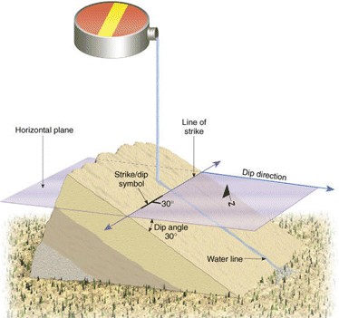
This orientation is typically written in the unambiguous format AAA/BB, where AAA is the dip direction and BB is the dip. For example, a plane with a dip direction of 215 degrees and a dip of 26 degrees has an orientation of 215/26.
Formatting Structural Point Data
A structural points data file requires the following fields to be recognised by Stereonet Charts and by 3D windows as structural points:
-
XPT - X coordinate.
-
YPT - Y coordinate.
-
ZPT - Z coordinate.
-
DIPDIRN - Dip direction in degrees. Values range from 0 to 360 degrees, clockwise from north.
-
SDIP - Dip in degrees. Values range from 0 to 90 degrees, where 0 is horizontal and 90 is vertically down.
-
Other user-defined attribute fields.
User-defined attribute fields are used to:
-
Describe, categorise, and analyse structural data.
-
Filter data in the Design and windows.
-
Generate stereonets by key field values.
User-defined alphanumeric or numeric attribute fields can describe values such as:
-
Unique feature ID numbers.
-
Feature types, such as fault, joint, or bedding.
-
Date and location.
-
Surface roughness.
-
Joint compressive strength (JCS).
-
Rock type.
-
Gouge, or fill material.
The example structural points file used in the stereonet examples contains the following user-defined attribute fields:
-
SCANLNID - The scan line identifier, or scan line number.
-
AT - The distance along the mapping line at which the structure is located.
A scan line is a structural mapping method where each structure intersected along a mapping line is mapped. The mapped structures are not averaged or represented by a representative structural feature.
For examples that use structural data, see Stereonet Analysis - Exercises and Slope Failure Mode Analysis.
Related topics and activities: